Barred & Butter Islandsfrom Cape Rozier, near Castine Maine |
 |
| Paddle Trip
|
| Cape Rosier/Blake Point Cove to East
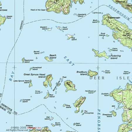
Barred and Butter Islands An 1 - 4 hours ocean trip from Bateman's Beach, Brooksville, ME. Highlights: Lovely islands in East Penobscot Bay, seals sunning on ledges near Pond Island, and great views from the top on Montserrat Hill on Butter Island Route: Jim Clause and I launched from Bateman's Beach at Blakes Point cove near Cape Rosier at 11:00 am in the morning of June 27, 2004. We paddled south past Pond Island to East Barred(about 3 nm) in about 50 minutes--arriving at 11:50. After a quick lunch we paddled southeast past Beach Island and the second Barred Island group to the beach on the northeast side of Butter. (about 3 nm) Butter is owned by the Cabot family who allow day trippers to land at two beaches, one, Nubble, on the eastern end of the Island and the other, Orchid, to the northwest of the first. Hikers are encouraged to climb Montserrat Hill but are cautioned to stay on the trail as the rest of the Island is off limits to the public. MITA members may camp but only with prior reservations from the caretaker. (see the 2004 MITA guidebook). We left Butter at 2:00 pm and paddled straight back to Blake Point in a northwesterly course. By the time we left the wind had increased to 20 knots, gusting to 22 and the seas were running 2 to 3 feet. Because the wind was out of the southwest we got a push and arrived at Pond Island by 2:55 where we took a short break out of the wind in our boats. We left Pond at 3:00 and arrived back at Blake Point cove, about one nautical mile away, at 3:15. Safety Tips: This trip involves some rather long crossings(from Pond to East Barred--about 2 nm and from Butter directly back to Pond--about 4 nm) and should not be attempted in winds stronger than you would feel comfortable in. Some of the open stretches involve considerabe fetch and high seas can occur. The wind was blowing at 20 knots steady gusting to 22 knot on our return trip and the seas were about 3 feet(or a little higher) That was just at the point where I still am confident---had the winds been up to 25-30 knots I would have been white knuckled on the way back. The wind picked up from 5-10 knots in the morning to 20 knots in the afternoon out of the south west. This was predicted on the weather radio and is common on the coast of Maine in the summer. If the wind were blowing hard (over 15 knots) out of the north, the return leg of this trip would have been difficult. Paddlng Tips: Although not an epic, this trip is still a serious undertaking and should not be attempted by inexperienced paddlers (without an experienced guide) nor should it be attempted in bad weather---high winds, fog, etc. as it involves fairly long (3nm) open stretches with considerable exposure. Be sure to listen to a forecast prior to leaving and keep an eye out for weather changes while on the water. take outs and rest stops=Pond Island and East Barred Island are both public islands and worth stopping at. When stopping at East Barred do not go to West Barred as that is a seabird nesting site. Comments: Jim Clause paddled this trip on June 27, 2004 in his hand made Shearwater Merganzer accompanied by Jon Sprague in a Wilderness Systems Tempest 170 --Contributed by Jon Sprague |
 |
||
| Previous Trip | Next Trip | List of Trips | Submit a Trip | Home |