Sandy Hook Bayfrom Fair Haven, NJ |
|
| Paddle Trip |
| State Navesink River to
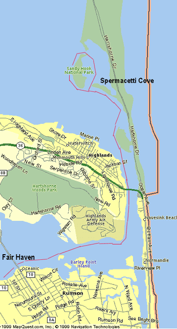
Shrewsbury River to Sandy Hook Bay & Back, New Jersey The Road Trip: Using the Garden State Parkway, get off at Exit 109 (Red Bank/Lincroft), at the end of the exit stay in the LEFT lanes and at the traffic signal cross Newman Springs Rd and continue on Half Mile Rd. At the next traffic signal, turn RIGHT onto West Front Street. Continue on West Front Street. It becomes River Rd in Fair Haven. Continue on River Rd (look for the Fair Haven Volunteer Fire Co on the left - you're almost there). Continue on River Rd to Fair Haven Rd (traffic signal & Fair Haven Hardware Store on the right with Blue Awnings). Turn LEFT at Fair Haven Rd and drive to the end and park only on the right side of the road. This is a residential area, but the launch area is part of Green Acres (public land). |
 |
||
| The Launch: Carry
your boats about 100 ft to the waters edge. This is a small public area. Start
paddling EAST (to the right). Time and distance This trip takes approximately 5-6 hours and covers approximately 15 miles (round trip). Keep in mind that this trip is on tidal waters, so you must calculate the tides. You want to leave Fair Haven on a ebb high tide. It's easy. Determine when high tide occurs at Sandy Hook and add 3 hr 28 min for Fair Haven. Example: Sandy Hook (high tide) is 5:00 am, depart Fair Haven at 8:28 am. The next tide calculation is when to start the return trip. Sandy Hook (high tide) plus 7 hr 20 min. (Example: 5:00 am plus 7:20, depart Spermacetti Cove at 12:20. Route: Depart Fair Haven (heading east - towards your right). You'll be passing through a lot of anchored sailboats. As you head east, look for a bridge (Oceanic Bridge). Paddle towards the right end of the bridge (not towards the mid-channel). Big houses along the shoreline. As you pass under the bridge, continue along the right side until the Navesink begins to narrow and gradually head for the opposite shoreline (all trees). Depending on time of the year, watch for power boats in the main channel as you cross. Now, follow the left shoreline (becomes too shallow for power boats). Where the Navesink meets the Shrewsbury, bear left (following the shore line). You should now be able to see the Route 36 bridge. Head towards the left side of the bridge (DO NOT ATTEMPT TO PADDLE THROUGH THE MAIN CHANNEL UNDER THE BRIDGE). Right before the bridge is a small beach - good rest stop. At this point look at the bridge piers, you'll appreciate the speed of the ebb tide. Go under the bridge and past a few marinas. Continue along the left side and a about 100-200 yards beyond the bridge look for a green buoy (#11). Watch for any power boats and begin to cross to the right shoreline (Sandy Hook National Park). Follow the shoreline heading (northeast) for an island. As you close in on the island, head for the left side and go around the island (you're now at Spermacetti Cove). As you continue around the island there's nice sandy beaches to stop, swim, etc. Continue on around the island and look for two old concrete ammo bunkers. Head for the shore and explore. Great urban cave art inside. It should take you about 2 1/2 hrs to 3 hrs to get to this point. You'll have until return trip time (refer to tide calc time for return trip in item 4 above) to rest, eat, swim, explore, etc. (about 1 1/2). Just reverse the route with an incoming (flood) tide. Paddling Tips: Depart Fair Haven 3 hr 28 minutes after high tide at Sandy Hook. Depart Spermacetti Cove area 7 hr 20 minutes after high tide at Sandy Hook. Watch out for: Depending on the time of year (summer weekends) boat traffic can be heavy under the Route 36 bridge. Landmarks: Oceanic Bridge, Route 36 Bridge, Sandy Hook National Park, Twin Lighthouses of Navesink. Stretch Your Legs: Spermacetti Cove & abandonded Ammo Bunkers One Paddler's Story: This trip has been done twice by members of the Kayak Touring Group (very informal club) of Central NJ. The group paddles recreational/touring kayaks (10 ft to 16 ft). For more info, contact: John (jonesjeep@aol.com) |
|
||
| Previous Trip | Next Trip | List of Trips | Submit a Trip | Home |